
Ahtna subsidiaries excel in a variety of business activities, including:
- Civil and Vertical Construction
- Environmental Remediation
- Facilities Management and Support
- Food Service
- Forestry and Gravel Sales
- Healthcare and Medical Records
- Janitorial
- Oil & Gas Pipeline Maintenance and Construction
- Staff Augmentation
- Surveying
- Security
- Logistics
- Training Range Operations
Except for Ahtna Development Company, LLC, all Ahtna subsidiaries are managed by Ahtna Netiye’, LLC. Ahtna Netiye’ (Netiye’ is an Ahtna Athabascan word meaning “our strength”) provides strategic direction and corporate structure for the Ahtna family of companies, fostering long-term growth and success.
Ahtna Netiye’, LLC is headquartered in Anchorage, Alaska, and is headed by CEO Roy Tansy Jr.
A.A.A. Valley Gravel, LLC
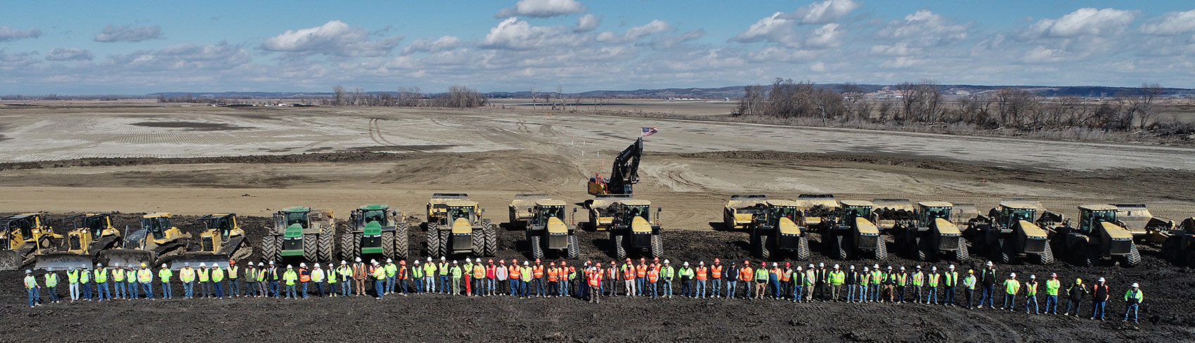
A.A.A. Valley Gravel, LLC is a sand and gravel mining, trucking, and asphalt operation strategically located to support transportation projects in the Matanuska-Susitna Valley of Alaska. A.A.A. Valley Gravel, LLC is headquartered in Palmer, AK and is SBA 8(a) and HUBzone certified. The company has served the Mat-Su Boroughs’ and Anchorage Municipality’s commercial and residential needs for 30 years with its gravel pit and asphalt operations.
Dave O’Donnell
President
1100 Little Brook Lane
Palmer, AK 99645
Office: (907) 745-8199
www.alaskavalleygravel.com
Ahtna Construction & Primary Products Company, LLC
Ahtna’s very first subsidiary company, Ahtna Construction & Primary Products Company, LLC (AC&PPC), was formed in 1974 and has been in business for over 45 years. Ahtna Construction specializes in civil construction, pipeline maintenance, emergency preparedness, and oil spill response and prevention. A union company, Ahtna Construction is fully licensed, insured and bonded, with established financial resources. Ahtna Construction has offices in four Alaska locations: Anchorage, Palmer, Fairbanks and Glennallen.
Dave O’Donnell
President
110 W 38th Avenue, Suite 100D
Anchorage, AK 99503
Office: (907) 929-5612
Fax: (907) 929-5713
Toll Free: (877) 374-0945
www.ahtnaconstruction.com
Ahtna Design-Build, Inc.
Ahtna Design-Build, Inc. (ADB) is an infrastructure and design-build company that provides construction, engineering, environmental remediation, design, renovation and facility improvement services nationwide. ADB holds certification as an SBA 8(a) company, with a Mentor-Protégé Joint Venture Agreement with CDM Smith, a world-renowned design firm. Additionally, as a nationally certified Minority Business Enterprise (MBE) and Disadvantaged Business Enterprise (DBE), ADB has established relationships with other prime contractors, allowing it to meet supplier diversity goals for public and private clients across the U.S. ADB has solid financial standing and our bonding capacity is $50M single project and $300M aggregate.
Craig O’Rourke
President
3200 El Camino Real #240
Irvine, CA 92602
Office: (714) 824-3471
www.ahtnadb.com
Ahtna Development Company, LLC
Ahtna Development Company, LLC (ADC) is currently focused on providing real property management and site-development opportunities – including commercial, retail and tourism development – throughout the Ahtna region and California. In Alaska, its focus areas include Anchorage, Cantwell, Copper Center and Glennallen. ADC is a graduate of the SBA 8(a) program.
Michelle Anderson
President
PO Box 649
Glennallen, AK 99588
Office: (907) 868-8250
Fax: (907) 868-8285
Ahtna Facility Services, Inc.
Ahtna Facility Services, Incorporated (AFSI) offers full-service environmental consulting and remediation, integrated facilities operations and maintenance, military family housing maintenance, logistics, armed and unarmed security, grounds maintenance, and healthcare aseptic janitorial services. As a firm specializing in military, government and commercial contracts, AFSI’s professional staff is dedicated to successfully meeting each customer’s mission requirements. This attention to customer needs, as well as the company’s dedication to quality, efficiency and effectiveness, has allowed AFSI to become an industry leader. AFSI is a graduate of the SBA 8(a) program.
Brenda Rebne
President
110 W 38th Avenue, Suite 200E
Anchorage, AK 99503
Office: (907) 868-8261
Fax: (907) 868-8217
Visit our webpage for more details
Ahtna Government Services Corporation
For more than 20 years, Ahtna Government Services Corporation (AGSC) has maintained a strong presence as a full-service, self-performing contractor with experience across the U.S. and in over 30 countries. AGSC’s highly qualified project managers, engineers and scientists are long-time experts in civil infrastructure, vertical construction, earthworks, environmental remediation, SWPPP/ BMP services, communications-tower renovation, design-build, demolition, marine construction, operations and maintenance, building renovation, and homeland security. Since its inception in 1999 and graduation from the SBA 8(a) program in 2008, AGSC has consistently delivered high-quality construction services to its clients. The company has grown and developed as one of the industry’s most trusted and respected small business contractors, serving federal, public agencies and private companies. AGSC is classified as a Small Disadvantaged Business and certified as a Minority Business Enterprise (MBE) through the California Public Utilities Commission (CPUC).
Craig O’Rourke
President
3100 Beacon Blvd.
West Sacramento, CA 95691
Office: (916) 372-2000
Fax: (916) 372-9401
www.ahtnagov.com
Ahtna Integrated Services, LLC
Brenda Rebne
President
110 W 38th Avenue, Suite 200O
Anchorage, AK 99503
Office: (907) 868-8261
Fax: (907) 868-8217
Visit our webpage for more details
Ahtna Logistics, LLC
Ahtna Logistics, LLC (ALL) is a certified 8(a) company that specializes in creating customized logistics solutions to support the growing need for dynamic, responsive, and reliable supply chain and lifecycle management in the government and commercial business sectors. We approach logistics management by employing concise concepts for providing solutions to our customers. This is accomplished through the integration of in-place systems and processes with efficient practices to develop scalable solutions. Focusing on the basic questions of what, when, where, and how, we are able to develop options for performance success and collaborate with our customers to determine the method that best meets their needs. In this way, ALL is able to produce customized programs that target client success.
Our management team brings together a group of proven professionals with successful experience in growing small, agile businesses in federal and commercial markets. ALL’s core capabilities are derived from our management team’s collective 150 plus years of experience in providing consistent and efficient services to our customers, and our first-hand performance experience with lifecycle support, inventory management and warehousing, and operations and management of training systems and facilities.
Jason McCart
President
jmccart@ahtna.net
110 W 38th Avenue, Suite 200I
Anchorage, AK 99503
27991 Buena Vista Blvd.
Los Fresnos, Texas 78566
Office: (907) 868-8255
Fax: (907) 334-6750
Private Security Board License: B19954701
Ahtna Marine & Construction Company, LLC
Ahtna Marine & Construction Company, LLC (AMCC) is a Florida-based dredging and civil construction firm specializing in hydraulic and mechanical dredging in lakes, ports, rivers, canals, inlets and other navigable waterways, as well as beach renourishment, shoreline protection, wetland construction, and environmental clean-up and maintenance. AMCC plans to establish a HUBZone office in Florida and service the U.S. Army Corps of Engineers, the Florida Inland Navigation District, and the Naval Facilities Engineering Command (NAVFAC) Southeast contracting office.
Craig O’Rourke
President
3200 El Camino Real #240
Irvine, CA 92602
Office: (714) 824-3471
444 W. Boynton Beach Blvd. #E
Boynton Beach, FL 33435
Office: (954) 568-0007
Ahtna Professional Services, Inc.
Ahtna Professional Services, Inc. is a certified 8(a) company that provides security, investigation, intelligence and consulting services for federal, state and local governments, as well as commercial and private sector clients. APSI provides specialized security, firefighting, rescue, para-medical and emergency management services. In addition, we provide facility maintenance, custodial and base operations management.
Texas Security License Number: B24047301
Brenda Rebne
President
110 W 38th Avenue, Suite 200F
Anchorage, AK 99503
Office: (907) 868-8261
Fax: (907) 868-8217
Visit our webpage for more details
Ahtna Support & Training Services, LLC
Ahtna Support and Training Services, LLC (AhtnaSTS), is focused on simulations and training support, instruction, planning and operations support, logistics, weapon system/platform lifecycle support, detention and food services, and warehouse operations and maintenance. AhtnaSTS earned its reputation as an industry leader through a combination of cutting-edge technology, a qualified and professional workforce, superior work management systems and procedures, and performance metrics and process improvements. AhtnaSTS has extensive knowledge of military training range operations, to include traditional and automated/digital environments, MOUTs and shoot houses, and targetry operations and maintenance. Training aids, devices, simulators, and simulations (TADSS) expertise includes nearly all MILES variants, as well as several weapons, vehicle, and communications systems, to include system design and up to depot-level maintenance. AhtnaSTS headquarters are located in Anchorage, Alaska, and are supplemented with program management, business development, and project-site offices across the country, allowing AhtnaSTS to quickly react to requirements throughout the U.S., the Pacific Rim and emerging markets to the east. AhtnaSTS is a graduated 8(a) company, originally organized in 2005.
Jason McCart
President
jmccart@ahtna.net
110 W 38th Avenue, Suite 200D
Anchorage, AK 99503
27991 Buena Vista Blvd.
Los Fresnos, Texas 78566
Office: (907) 334-6477
Fax: (907) 334-6750
www.ahtnasts.com
Private Security Board License: C19599
Training School License: F01346
Ahtna Technical Services, Inc
Ahtna Technical Services, Inc (ATSI) utilizes the latest technology, resources and management techniques to provide security services to the public sector and commercial entities. These services include armed and unarmed guard services, detention services, security screening, transportation, food services, operations and maintenance, and facility management. ATSI has extensive detention center and security guard experience stemming from its management of several U.S. Immigration and Customs Enforcement detention center facilities, where the company demonstrated a high level of knowledge and capabilities with all contractual standards and regulations. ATSI develops and implements training and quality control programs and has received exceptional business results during rigorous Performance-Based National Detention Standards (PBNDS) inspections, as well as American Correctional Association (ACA) audits. ATSI also delivers best-in-class small and large facilities operations and maintenance services by self-performing the majority of its programs. Customers count on ATSI for cost-effective facilities management solutions. The company was established in 1999 and graduated from the SBA 8(a) program in 2010.
Brenda Rebne
President
110 W 38th Avenue, Suite 200C
Anchorage, AK 99503
Office: (907) 868-8261
Fax: (907) 272-6356
Visit our webpage for more details
AKHI, LLC
Founded in 2005, AKHI is a certified 8(a) company providing responsive, customer-oriented services throughout the U.S. Our diverse capabilities and services include: Base Operation Support (BOS) Services: Maintenance & Logistics; Administration, Management & Training; Homeland Security; Information Technology; and Engineering. Our years of experience demonstrate AKHI’s ability to continue serving clients as a long-term, strategic service provider as well as a reputable and financially stable teaming partner.
AKHI brings a wealth of knowledge and expertise and an uncompromising focus on safety, loyalty, dedication, integrity, and project ownership. We continually strive to build trust, confidence, and responsiveness in all our client relationships and believe in partnering with our customers. AKHI provides skilled employees who are well versed in the successful operation of long-term contracts with recognized excellence in quality and customer service.
Brenda Rebne
President
110 W 38th Avenue, Suite 200H
Anchorage, AK 99503
Office: (907) 868-8261
Visit our webpage for more details
Ahtna Diversified Holdings
Ahtna Diversified Holdings, LLC (ADH) is a holding company for seven subsidiaries within the Ahtna Family of Companies. ADH has ANC 8(a) and Small Disadvantaged Business contracting capabilities focused on safely delivering construction, environmental, technology, and professional services with expertise in program and project management, contract administration, and financial accountability.
Ahtna Builders, LLC
Ahtna Builders, LLC (ABL) is a wholly owned subsidiary of Ahtna Diversified Holdings, LLC. Our team is purpose driven, with a focus on safely delivering quality projects to our clients and our communities. We partner with state and national government agencies to deliver innovative solutions for mission success. We leverage our civilian and commercial expertise to provide comprehensive infrastructure, facilities, and civil works services for our clients’ most challenging projects. Our project management teams are laser-focused on exceptional client service and flawless execution – helping strengthen critical infrastructure for generations to come.
Established in 2023, ABL is a self-performing contractor with experienced project managers, as well as technical, administrative, and field staff providing a broad spectrum of services in managing construction, environmental, technology, and professional services projects.
Tim Finnigan, President
Ron DesGranges, Day-to-day Manager
David Bennett, Director of Business Development
110 W 38th Avenue, Suite 200U
Anchorage, AK 99503
Office: (907) 313-1740
Fax: (907) 272-6356
Visit our webpage for more details
Ahtna Engineering Services, LLC
As a subsidiary under Ahtna Diversified Holdings, LLC, Ahtna Engineering Services, LLC (AES) is a full-service company who provides a wide range of services nationwide and has the resources in place to support multiple, concurrent task orders and contracts, as well as the ability to respond to surge requirements, maximize regional knowledge, and manage costs. Our primary services include design-build, construction, demolition, renovations, environmental, oil and gas, and professional and technical services. AES maintains a multi-disciplinary core staff of professionals with decades of experience, including project managers, QA/QC and safety managers, engineers, scientists, and construction supervisory and craft personnel.
Tim Finnigan, President
Greg Jarrell, Day-to-day Manager
David Bennett, Director of Business Development
110 W 38th Avenue, Suite 200A
Anchorage, AK 99503
Office: (907) 646-2969
Fax: (907) 561-5475
Visit our webpage for more details
Ahtna Environmental Inc.
Ahtna Environmental, Inc. (AEI) is a subsidiary of Ahtna Diversified Holdings, LLC. AEI is a self-performing contractor with experience in managing environmental and construction projects. AEI staff include experts in program/project management, as well as technical, administrative, and field staff, enabling AEI to provide a broad spectrum of services with unmatched success in developing, evaluating and deploying innovative environmental solutions. AEI has extensive experience with environmental issues and a significant understanding of environmental laws and regulations that are currently facing various federal agencies. AEI’s services are managed by dedicated and recognized leaders and backed by a commitment to safety and quality.
Tim Finnigan, President
Chuck Holman, Day-to-day Manager
David Bennett, Director of Business Development
110 W 38th Avenue, Suite 200B
Anchorage, AK 99503
Office: (907) 644-0760
Fax: (907) 272-6356
Visit our webpage for more details
Ahtna Global, LLC
As a subsidiary under Ahtna Diversified Holdings, LLC, Ahtna Global, LLC (AGL) provides full-service general contracting, construction management, and design/build services for projects of varying sizes and complexities. AGL’s multi-disciplinary core staff includes construction supervisors, engineers, scientists, and craft labor. As an SBA-certified Alaska Native Corporation (ANC) 8(a), AGL offers unique, flexible, and streamlined procurement options to our customers. Direct-award contracting opportunities present many benefits to our clients, including an accelerated procurement timeline, competitive rates, help meeting socio-economic contracting goals, and a virtually unlimited direct award ceiling.
Tim Finnigan, President
Ron DesGranges, Day-to-day Manager
David Bennett, Director of Business Development
110 W 38th Avenue, Suite 200J
Anchorage, AK 99503
Office: (907) 569-8250
Visit our webpage for more details
Ahtna Infrastructure & Technologies, LLC
Ahtna Infrastructure & Technologies, LLC (AITL) is managed under Ahtna Diversified Holdings, LLC providing full-service general contractor, construction management, and design/build services for projects of varying sizes and complexities. We consistently deliver technical competency, cost efficiency, and a zero-risk tolerance to ensure the needs of our clients are met every time. AITL’s multi-disciplinary core staff includes construction supervisors, engineers, scientists, and craft labor.
As a certified SBA 8(a) company, we offer unique, flexible, and streamlined procurement options to our customers. Direct-award contracting opportunities present many benefits to our clients, including an accelerated procurement timeline, competitive rates, help meeting socio-economic contracting goals, and a virtually unlimited direct award ceiling.
Tim Finnigan, President
Bernard Wong, Day-to-day Manager
David Bennett, Director of Business Development
110 W 38th Avenue, Suite 200M
Anchorage, AK 99503
Office: (907) 279-7077
Visit our webpage for more details
Ahtna Solutions, LLC
Ahtna Solutions, LLC (ASL) is a certified 8(a) self-performing ANC Federal Government Contractor managed under Ahtna Diversified Holdings, LLC.
ASL was established in December 2018 to complement AI’s current subsidiaries’ operations and fulfills the growing need to provide professional services, environmental, construction, and technology services to the government and private sector clients. The firm received its 8(a) certification through the Small Business Administration in December 2019 and will maintain that status until December 2029. As an 8(a) firm, we provide the flexibility and responsiveness of a dynamic small business, with a government-proven infrastructure to minimize performance risk and maximize cost-effective and efficient project execution.
Tim Finnigan, President
Bernard Wong, Day-to-day Manager
David Bennett, Director of Business Development
110 W 38th Avenue, Suite 200L
Anchorage, AK 99503
Office: (907) 563-3233
Fax: (907) 561-5475
Visit our webpage for more details
Blackburn Environmental
As a subsidiary of Ahtna Diversified Holdings, LLC established in 2023, Blackburn Environmental, LLC works closely with clients and communities to solve the most complex project challenges. Our broad environmental services help the private and public sectors achieve compliance and reduce or eliminate risks while protecting our natural environment.
Ahtna has a skilled logistics team dedicated to managing the movement of staff and equipment to remote sites nation-wide. We understand the challenges of remote work and how to plan for contingencies in logistical transport. We know how to execute this work and anticipate and plan for contingencies. Blackburn Environmental’ s broad capabilities, combined with our deep understanding of local cultures and regulatory practices, provide clients with a single source for project delivery.
Tim Finnigan, President
Kelly O’Meara, Day-to-day Manager
David Bennett, Director of Business Development
110 W 38th Avenue, Suite 200V
Anchorage, AK 99503
Office: (907) 308-3216
Fax: (907) 272-6356
Visit our webpage for more details